Coordinate Systems and EPSG Codes in Korea: Belt TM, UTM-K, and Why 5181 Is Not 5186
The first thing I check on any GIS dataset is its coordinate reference system. The metadata often gives only a number such as "EPSG:5186", and data for the same area in Korea can arrive as 5181, 5186, 5179 or 4326. The numbers alone do not tell you which ones match and where they will disagree. From now on, this blog writes the name and the EPSG code together the first time a coordinate system appears in a post (for example, East Belt (GRS80) EPSG:5187). This post sets out the lookup table behind that rule and the places where it actually goes wrong in practice.
The basic difference between geographic and projected coordinate systems is covered in Coordinate Systems in QGIS: EPSG:4326 vs EPSG:5186. Here I focus on the codes you meet in Korean data and how they differ.
What an EPSG code bundles
To turn a pair of numbers into one point on the ground you need several things: the ellipsoid that approximates the Earth, how that ellipsoid is tied to the Earth (the geodetic datum), the map projection, the origin, and the false easting and northing added to it. An EPSG code is a number attached to that whole bundle. The list was started by the European Petroleum Survey Group and is now maintained by IOGP as the EPSG registry (epsg.org). QGIS, GDAL and PostGIS all look coordinate systems up by this number.
So a different number means something in the definition is different. Two systems with similar names but different codes must not be treated as the same. EPSG:5181 and EPSG:5186, discussed below, are the classic case.
Coordinate systems used in Korea and their EPSG codes
This is the lookup table commonly used for Korean data, with the projection parameters added. The parameters are the values PROJ (pyproj) reads from the EPSG registry definitions.
| Coordinate system | EPSG code | Ellipsoid | Origin and projection parameters |
|---|---|---|---|
| Bessel geographic | 4004, 4162 | Bessel 1841 | Latitude/longitude, no projection. 4162 is the Korean 1985 datum |
| WGS84 geographic | 4326, 4166 | WGS 84 | Latitude/longitude, no projection. 4166 is the Korean 1995 datum |
| West Belt (GRS80) | 5185 | GRS80 | TM, 38°N 125°E, scale factor 1, false easting 200,000 m, false northing 600,000 m |
| Central Belt (GRS80) | 5186 (5181) | GRS80 | TM, 38°N 127°E, scale factor 1, false easting 200,000 m, false northing 600,000 m. 5181 uses a false northing of 500,000 m |
| East Belt (GRS80) | 5187 | GRS80 | TM, 38°N 129°E, scale factor 1, false easting 200,000 m, false northing 600,000 m |
| East Sea (Ulleung) Belt (GRS80) | 5188 | GRS80 | TM, 38°N 131°E, scale factor 1, false easting 200,000 m, false northing 600,000 m |
| UTM-K (GRS80) | 5179 | GRS80 | TM, 38°N 127.5°E, scale factor 0.9996, false easting 1,000,000 m, false northing 2,000,000 m |
| Google Mercator | 3857 (900913) | WGS 84 (computed on a sphere) | Web Mercator. 900913 is the alias used before the official registration |
The four belt TM systems share the latitude of origin (38°N), the scale factor (1) and the false easting and northing (200,000 m and 600,000 m). Only the central meridian changes, in 2° steps, and each system covers a 2° band of longitude, 1° either side of its central meridian. That is why data for Gyeonggi and Chungcheong comes in the Central Belt, and data for eastern Gangwon and Gyeongsang in the East Belt. UTM-K was designed to cover the whole country in one system without belts, so it has a single central meridian at 127.5°E and a scale factor of 0.9996.
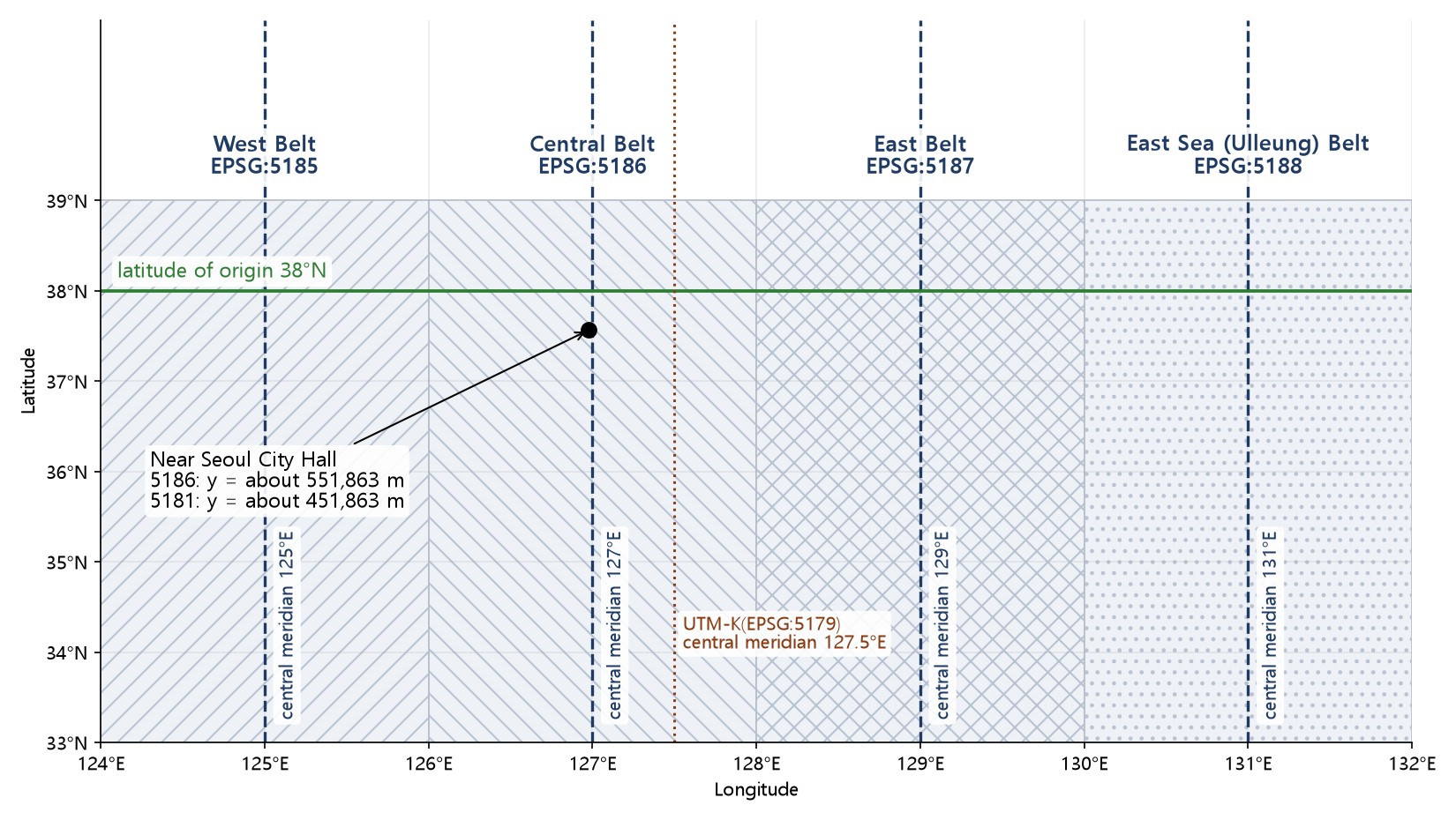
Same Central Belt, 100 km apart: 5181 and 5186
This is the mistake I see most often. Both systems are called "Central Belt (GRS80)" and share the origin and central meridian. The only difference is the false northing: 5181 adds 500,000 m and 5186 adds 600,000 m. Converting a point near Seoul City Hall (37.5663°N, 126.9779°E) into both shows it plainly.
| Coordinate system | X (m) | Y (m) |
|---|---|---|
| Central Belt (GRS80) EPSG:5181 | 198,047.5 | 451,862.8 |
| Central Belt (GRS80) EPSG:5186 | 198,047.5 | 551,862.8 |
| UTM-K (GRS80) EPSG:5179 | 953,892.2 | 1,952,009.9 |
X is identical and Y differs by exactly 100,000 m. If you assign 5186 to data that is really in 5181, the whole layer is drawn 100 km too far north. Its shape looks fine, so people tend to look for the cause elsewhere. The coordinates themselves give a hint: Central Belt data near Seoul with Y around 450,000 m is probably 5181, around 550,000 m probably 5186. The EPSG registry records 5181 as replaced by 5186 from 2010, but 5181 still shows up in some web map services and in older datasets.
Old Bessel-based data needs more than a new code
The Bessel geographic codes (4004, 4162) belong to the pre-world-geodetic-system era and use the Bessel 1841 ellipsoid. Old TM data built on them (for example EPSG:5174, Korean 1985 / Modified Central Belt) differs from the GRS80 systems in both ellipsoid and datum. 5174 even defines its central meridian as 127.0028903°E rather than 127°E; according to the EPSG remarks this corrects a 10.405″ longitude difference.
Moving such data into a GRS80 system means a datum transformation followed by reprojection, not just assigning a new code. Transforming the Seoul City Hall point with the registry's default transformation (Korean 1985 to KGD2002 (1)) moves it about 362 m, which is how far off the data will sit if you only relabel it. For public surveying or cadastral work, check the transformation method and parameters published by the National Geographic Information Institute. The 362 m is one example transformation; I did not test the accuracy of different methods here.
Geographic coordinates are not all the same: 4326, 4166, 4737
Latitude/longitude data is usually WGS84 geographic, EPSG:4326. There are also codes named after Korean datums: 4166 (Korean 1995) uses the WGS 84 ellipsoid, and 4737 (KGD2002), the Korean world geodetic system, uses GRS80. The two ellipsoids differ so little that general GIS work often treats them as the same, but when handling survey results it is safer to write the name and code separately.
Do not measure distance or area in Google Mercator (3857)
Most basemap tiles are Google Mercator, EPSG:3857. I listed 900913 next to it because it is the alias used before 3857 was formally registered. 3857 is convenient for display but inflates distance and area as latitude increases. Even at Korean latitudes (33 to 38°N) lengths are 1.19 to 1.27 times and areas 1.42 to 1.61 times too large, so lengths and areas measured in it must not be reported as they are. Reproject to a belt TM system or UTM-K first.
Checking and fixing it in QGIS
- Check first. Look at the CRS name and code under Layer Properties → Information. The project CRS in the bottom-right corner is a separate setting from the layer CRS.
- Look at the numbers. Click a point with the Identify tool and compare the size of X and Y with the false easting and northing in the table. For Central Belt data, whether Y is around 450,000 or 550,000 m is the first clue.
- Tell "assign" from "transform". Use Set Layer CRS only when the file's CRS is missing or wrong. To change the coordinate values into another system, use Reproject Layer in the Processing Toolbox, or choose the target CRS when exporting. Assigning keeps the numbers and changes how they are read; transforming changes the numbers.
- Check the result. Overlay the layer on a basemap or reference data and compare the coordinates of one known point.
The notation rule for this blog
From now on, practice and concept posts give the name from the table above together with the EPSG code the first time a coordinate system appears: "East Belt (GRS80) EPSG:5187" for Korean systems and "NAD83 UTM 13N EPSG:26913" for overseas sample data. The same rule has been applied to the earlier Korean practice posts.
Work notes
- The projection parameters, the Seoul City Hall coordinates and the 4162 to 4737 shift (about 362 m) were checked by reading the EPSG definitions and transforming with pyproj (PROJ). The input point 37.5663°N, 126.9779°E is an approximate illustrative location.
- The Google Mercator length and area factors were computed as sec φ and sec² φ at 33° and 38° latitude.
- The names and EPSG codes follow the lookup table commonly used for Korean data and were cross-checked against EPSG registry names (such as KGD2002 / Central Belt 2010).
- Figure 1 is a schematic drawn with matplotlib, without coastlines or administrative boundaries.
- The accuracy of datum transformations for Bessel-based data was not tested in this post.
This is an English adaptation of a Korean post on the GeoAI blog. The original is here.
This post was drafted with the help of AI tools and reviewed by the author. Tool features and data portals change over time, so check the official documentation when you practice.


Comments
Post a Comment